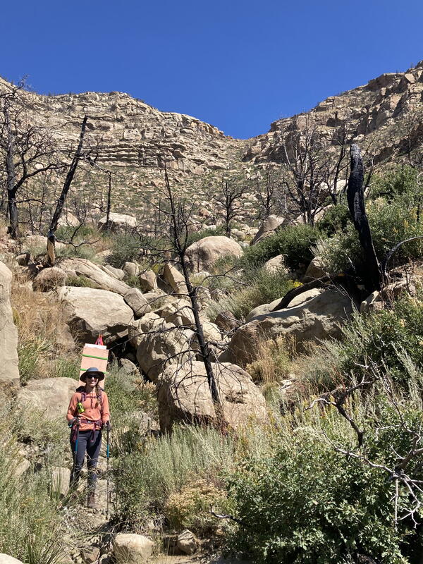
USGS scientist reviews the imagery being acquired from a UAS at the Cimarron Canyon in New Mexico
linkUSGS scientist Mark Bauer reviews the imagery being acquired from a UAS at the Cimarron Canyon in New Mexico
An official website of the United States government
Here's how you know
Official websites use .gov
A .gov website belongs to an official government organization in the United States.
Secure .gov websites use HTTPS
A lock () or https:// means you’ve safely connected to the .gov website. Share sensitive information only on official, secure websites.
The U.S. Geological Survey (USGS) National Uncrewed Systems Office (NUSO) leads the research activities needed to make Uncrewed Aircraft Systems (UAS) data collection an efficient, safe, and cost-effective remote sensing tool for Department of the Interior (DOI) and USGS scientists.
DOI manages over 20 percent of the Nation’s public lands and is responsible for migratory bird and wildlife conservation; historic preservation; endangered species conservation; surface-mined lands protection and restoration; and mapping, geological, hydrological, and biological science for the Nation. Access to remotely sensed data is critical to fulfilling the DOI’s commitment to providing the best available science over such diverse missions and extensive landscapes. UAS is a tool that has quickly become vital to scientists by delivering some of the best remotely sensed data available over DOI’s expansive geography. UAS can also carry sophisticated high-resolution sensors that offer impressive capabilities relative to the amount, resolution, persistence, and flexibility of remotely collected data for these challenging locations.
USGS scientist Mark Bauer reviews the imagery being acquired from a UAS at the Cimarron Canyon in New Mexico
UAS ground control point survey targets deployed along the Cimarron Canyon in New Mexico
One of the ground control point survey targets deployed along the Paleocene Poison Canyon Formation in the Cimarron Canyon and used to provide accurate GPS data during the UAS data collection flights.
UAS ground control point survey targets deployed along the Cimarron Canyon in New Mexico
One of the ground control point survey targets deployed along the Paleocene Poison Canyon Formation in the Cimarron Canyon and used to provide accurate GPS data during the UAS data collection flights.
USGS scientist Victoria Scholl (NUSO) places a scale bar and ground control point survey target along the Paleocene Poison Canyon Formation in the Cimarron Canyon. GPS data from these targets and derived from the UAS collected imagery helps ensure high positional and geometric accuracy of georeferenced data products including 3D models.
Prior to the UAS flights USGS researchers Amy Gilmer, Theresa Schwartz, and Victoria Scholl hike up Cimarron Canyon in New Mexico to place ground control targets and scale bars.
USGS remote pilot Mark Bauer flies a UAS with a stabilized gimbal with vibration dampening mounted with a Sony A7r camera with a locked focus using a 14mm wide angle lens at the Cimarron Canyon in New Mexico.
In June 2021, eight months after the East Troublesome Fire burned over 193,000 acres in Colorado, NUSO performed UAS data collection over several of the burn scars representing different fire intensity levels and fuel types.
Ricoh GR natural color image taken from a UAS showing the intertidal biofilm, a slimy green layer of fungi and bacteria growing on top of mud, in San Francisco Bay, California.
USGS scientist Matt Burgess pilots a UAS during a joint USGS NUSO, USGS Western Ecological Research Center, USGS Western Geographic Science Center, USGS Spectroscopy Lab, and California State University Monterey Bay multi-scale hyperspectral remote sensing data collection mission in San Francisco Bay, California.
Intertidal biofilm, a slimy green layer of fungi and bacteria growing on top of mud, inhabits mudflats and is an essential component of shorebirds’ diets in San Francisco Bay, California.
USGS scientist Joe Adams (NUSO) setting up a GPS base station for a snow mapping project in Winter Park, Colorado. GPS base station data is used in post-processing to improve the geospatial accuracy of UAS collected data.
Have you heard about biking to work? Well, how about trying snowshoeing to work?
Two UAS fly in formation during the joint NUSO and USGS Water Resources Mission Area snow water equivalent project in Winter Park Colorado. These two UAS are carrying identical, experimental, software-defined radar sensors for measuring snow depth and density.
USGS researcher Joe Adams (NUSO) mounts a Ricoh GRII camera to a UAS that will be flying transects to collect natural color imagery during the snow water equivalent (SWE) project in Winter Park Colorado.
A FireFLY6 Pro vertical takeoff and landing (VTOL) fixed-wing UAS sits on the ground between flights at the Corral Bluffs study area to support fossil studies by the Denver Museum of Nature & Science.
Image of the 2018 eruption of the Kilauea volcano taken from a Sony RX1R II natural color sensor mounted on a UAS
NUSO researchers Todd Burton and Joe Adams were part of the UAS response team that provided 24/7 aerial monitoring of the 2018 eruption of the Kilauea volcano in Hawaii.
DOI researchers Mark Feller (NUSO) and Jeff Safron at the UAS mission control station overlooking the Chase Lake National Wildlife Refuge
UAS launch site at Tomales Bay in California
The U.S. Fish and Wildlife Service (USFWS) partnered with the NUSO in December 2013 at the San Francisco Bay National Wildlife Refuge (NWR) Complex to test the use of UAS technology for surveying waterbird abundance and distribution.
UAS launch site at Tomales Bay in California
The U.S. Fish and Wildlife Service (USFWS) partnered with the NUSO in December 2013 at the San Francisco Bay National Wildlife Refuge (NWR) Complex to test the use of UAS technology for surveying waterbird abundance and distribution.
Check out -
Quick Link "UAS Supports Science" to see UAS data releases and related scientific journal articles