
San Francisco Bay-Delta
The Bay-Delta is a nexus for challenging issues about water, ecosystems, and human use. USGS science helps address key problems and uncertainties.
The Bay-Delta is a nexus for challenging issues about water, ecosystems, and human use. USGS science helps address key problems and uncertainties.
Grand Canyon Monitoring and Research Center
How does Glen Canyon Dam affect downstream Colorado River resources?
How does Glen Canyon Dam affect downstream Colorado River resources?
Lake Tahoe
An underwater view of periphyton growing on rocks near the shore of Lake Tahoe with a reflection of the rocks on the water surface
An underwater view of periphyton growing on rocks near the shore of Lake Tahoe with a reflection of the rocks on the water surface
Salton Sea
The Salton Sea is facing many challenges as inflows and water levels decline. USGS science helps identify problems and evaluate possible solutions.
The Salton Sea is facing many challenges as inflows and water levels decline. USGS science helps identify problems and evaluate possible solutions.
New Technologies for Mapping Surface Soil Moisture
Coastal Dwellers
Southwest Region
The Southwest Region covers Arizona, California, Nevada, and a portion of southern Oregon. Our scientists do a broad array of research and technical assistance throughout the U.S. and across the globe. The Regional Office, headquartered in Sacramento, provides Center oversight & support, facilitates internal & external collaborations, and works to further USGS strategic science direction.
News
2025 in Review: The Saline Lake Ecosystems Integrated Water Availability Assessment
2025 in Review: The Saline Lake Ecosystems Integrated Water Availability Assessment
AquaDePTH: Merging Aquatic Disease Surveillance Data into One Useful Tool
AquaDePTH: Merging Aquatic Disease Surveillance Data into One Useful Tool
RAMPS Newsletter - Fall 2025
RAMPS Newsletter - Fall 2025
Publications
Imperiled Great Basin terminal lakes: Synthesizing ecological and hydrological science gaps and research needs for waterbird conservation Imperiled Great Basin terminal lakes: Synthesizing ecological and hydrological science gaps and research needs for waterbird conservation
Terminal lakes are declining globally because of human water demands, drought, and climate change. Through literature synthesis and feedback from the resource and conservation community, we review the state of research for terminal lakes in the Great Basin of the United States, which support millions of waterbirds annually, to prioritize ecological and hydrologic information needs. From...
By
Ecosystems Mission Area, Water Resources Mission Area, Species Management Research Program, Water Availability and Use Science Program, Forest and Rangeland Ecosystem Science Center, Fort Collins Science Center, Nevada Water Science Center, Oregon Water Science Center, Utah Water Science Center, Western Ecological Research Center (WERC), Saline Lake Ecosystems Integrated Water Availability Assessment
Bees of the Buenos Aires National Wildlife Refuge—A preliminary report on a bee survey in a vulnerable semi-desert grassland of the Sonoran Desert Bees of the Buenos Aires National Wildlife Refuge—A preliminary report on a bee survey in a vulnerable semi-desert grassland of the Sonoran Desert
Pollinators are vital to the continued existence and seed production of about 87.5 percent of all flowering plants (Ollerton and others, 2011). In the semi-desert grasslands of Buenos Aires National Wildlife Refuge, in the Sonoran Desert of the United States, flowering forbs provide seed vital to the food base of wildlife, including the 136 species of resident and migratory birds using...
Analyzing spatial distributions and alignments of pitted cone features in Utopia Planitia on Mars Analyzing spatial distributions and alignments of pitted cone features in Utopia Planitia on Mars
Martian geomorphology and surface features provide links to understanding past geologic processes such as fluid movement, local and regional tectonics, and feature formation mechanisms. Pitted cones are common features in the northern plains basins of Mars. They have been proposed to have formed from upwelling volatile-rich fluids, such as magma or water-sediment slurries. In this study...
Science

USGS Sagebrush Science: Supporting Public Safety and Economic Decision Making Across the West
The sagebrush biome is one of the largest ecosystems in North America. Encompassing nearly one-third of the continental U.S., it provides critical resources for millions of Americans and a home for hundreds of plants and animal species in the West. Natural resource management in sagebrush ecosystems can be complex, and science can support management decisions by providing knowledge and tools to...
By
Core Science Systems Mission Area, Ecosystems Mission Area, Biological Threats and Invasive Species Research Program, Climate Adaptation Science Centers, Cooperative Research Units, Land Management Research Program, Species Management Research Program, Earth Resources Observation and Science (EROS) Center , Forest and Rangeland Ecosystem Science Center, Fort Collins Science Center, Northern Rocky Mountain Science Center, Southwest Biological Science Center, Western Ecological Research Center (WERC), Wildland Fire Science
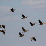
Tackling avian influenza with automated detection for an early warning system
The USGS is collaborating with agricultural and wildlife management partners to address the threat of highly-pathogenic avian influenza (HPAI) to wildlife, domestic poultry, and livestock. Partners include federal (U.S. Fish and Wildlife Service and U.S. Department of Agriculture) and non-federal agencies as well as State government, private organizations, and academic institutions. Our...
Drought versus Aridification in the Colorado River Basin
The Colorado River Basin is no stranger to drought. However, not all droughts are the same. Drought refers to a temporary state where conditions eventually return to normal. Aridification is the transition to persistent above-average dry conditions that do not return to normal. It is important to know whether the current, prolonged millennium drought (2000-present) is actually the first stages of...