
After Hurricane Michael obliterated Fish Inn, the sea turtle research team's field station, team members salvaged some of the building's floor tiles and made this sea turtle mosaic, which they plan to eventually install in a new field station.
Images
See our science through the images below.
Filter Total Items: 3147

A sea turtle mosaic made from the field station's broken floor tiles
After Hurricane Michael obliterated Fish Inn, the sea turtle research team's field station, team members salvaged some of the building's floor tiles and made this sea turtle mosaic, which they plan to eventually install in a new field station.

Alder root nodules
Root nodules are a symbiotic relationship between a plant and nitrogen-fixing bacteria. A symbiotic relationship is one where both organisms benefit. Nitrogen-fixing bacteria change inorganic nitrogen from the air into ammonia, a form of nitrogen most organisms can use.
Root nodules are a symbiotic relationship between a plant and nitrogen-fixing bacteria. A symbiotic relationship is one where both organisms benefit. Nitrogen-fixing bacteria change inorganic nitrogen from the air into ammonia, a form of nitrogen most organisms can use.

Miriam Jones holds a peat core in Alaska
Miriam Jones holding a peat core that was extracted from a thawed permafrost bog at the Alaska Permafrost Experiment (APEX) site at Bonanza Creek LTER, Alaska. The boundary between the formerly frozen permafrost plateau and thawed bog is visible in the peat stratigraphy, with the light-colored peat indicated thawed bog.
Miriam Jones holding a peat core that was extracted from a thawed permafrost bog at the Alaska Permafrost Experiment (APEX) site at Bonanza Creek LTER, Alaska. The boundary between the formerly frozen permafrost plateau and thawed bog is visible in the peat stratigraphy, with the light-colored peat indicated thawed bog.

Otter mom feed pup in Glacier Bay, AK
A sea otter mother feeds her pup in Glacier Bay, Alaska. USGS researchers study sea otter distribution and abundance in Alaska and other parts of the country.
A sea otter mother feeds her pup in Glacier Bay, Alaska. USGS researchers study sea otter distribution and abundance in Alaska and other parts of the country.

Autonomous Underwater Vehicle (AUV) ‘Tethys’
The USGS along with the Monterey Bay Aquarium Research Institute (MBARI) funded a pilot study to use a long-range AUV to study limnology of Lake Michigan. The AUV is pictured here being deployed in Lake Michigan to document variation in algae productivity at a whole-lake scale and compare 3-D spatial patterns in chlorophyll a to satellite estimates.
The USGS along with the Monterey Bay Aquarium Research Institute (MBARI) funded a pilot study to use a long-range AUV to study limnology of Lake Michigan. The AUV is pictured here being deployed in Lake Michigan to document variation in algae productivity at a whole-lake scale and compare 3-D spatial patterns in chlorophyll a to satellite estimates.

Blue spotted salamander
Eastern Iowa Ambystoma laterale - Blue-spotted Salamander. USGS ARMI photo by Evan S. Grimes
Eastern Iowa Ambystoma laterale - Blue-spotted Salamander. USGS ARMI photo by Evan S. Grimes

Gulf Coast Waterdog - Necturus beyeri
Source: USGS National Wetlands Research Center. Photographer: Brad M. Glorioso. St. Tammany Parish, Louisiana
Necturus beyeri - Gulf Coast Waterdog
Source: USGS National Wetlands Research Center. Photographer: Brad M. Glorioso. St. Tammany Parish, Louisiana
Necturus beyeri - Gulf Coast Waterdog

Map of AK showing probability of change occurrence
Map of Alaska showing probability (%) of change occurrence. Insets show fire boundaries from the Bureau of Land Management (BLM) Large Fire Database and Landsat 8 imagery (bottom right; 2016) north of Fairbanks, Alaska.
Map of Alaska showing probability (%) of change occurrence. Insets show fire boundaries from the Bureau of Land Management (BLM) Large Fire Database and Landsat 8 imagery (bottom right; 2016) north of Fairbanks, Alaska.

Image collage of USGS Ecosystems Mission Area scientists in the field.
Image collage of USGS Ecosystems Mission Area scientists in the field.
By
Image collage of USGS Ecosystems Mission Area scientists in the field.
By

Juvenile Salt Marsh Harvest Mouse (Reithrodontomys raviventris)
USGS wildlife biologists holding a juvenile salt marsh harvest mouse (Reithrodontomys raviventris). The species is listed as "endangered" under the Endangered Species Act of 1973.
USGS wildlife biologists holding a juvenile salt marsh harvest mouse (Reithrodontomys raviventris). The species is listed as "endangered" under the Endangered Species Act of 1973.

Male leafcutting bee (Megachile) approaching an Origanum
The alfalfa leafcutting bee (Megachile rotundata) is an introduced species common to Southwest Idaho. They originate from the old world, most likely from northeastern Africa or the Middle East. These bees are successful pollinators of various crops and have been imported to North America for use in agriculture and beekeeping.
The alfalfa leafcutting bee (Megachile rotundata) is an introduced species common to Southwest Idaho. They originate from the old world, most likely from northeastern Africa or the Middle East. These bees are successful pollinators of various crops and have been imported to North America for use in agriculture and beekeeping.

Dakota buckwheat flowers
Photograph of the flowers of Dakota wild buckwheat (Eriogonum visheri).
It is native to the Great Plains in the United States, where it is known from North Dakota, South Dakota, and Montana.
Photograph of the flowers of Dakota wild buckwheat (Eriogonum visheri).
It is native to the Great Plains in the United States, where it is known from North Dakota, South Dakota, and Montana.

Aquatic insect eggs just above the waterline along the Colorado River in Grand Canyon
Aquatic insect eggs are laid on rocks just at the waterline along the Colorado River in Grand Canyon and here they are exposed as the water levels fluctuate. Aquatic insects are an important part of the food base in the Colorado River, providing food for fish, bats, and birds. Aquatic insects need to stay damp to survive and hatch.
Aquatic insect eggs are laid on rocks just at the waterline along the Colorado River in Grand Canyon and here they are exposed as the water levels fluctuate. Aquatic insects are an important part of the food base in the Colorado River, providing food for fish, bats, and birds. Aquatic insects need to stay damp to survive and hatch.
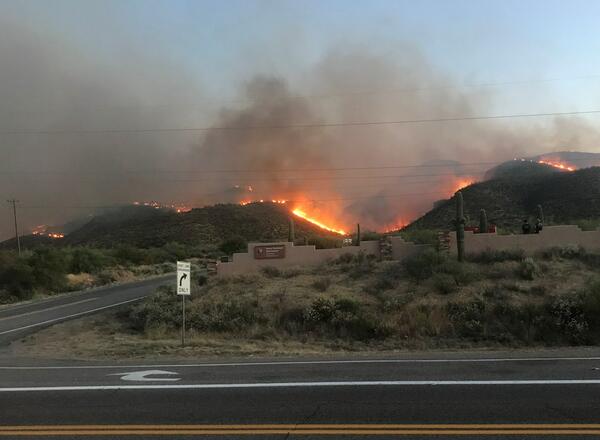
Flames from the Woodbury Fire rise above Tonto National Monument
Flames from the Woodbury Fire rise above Tonto National Monument.
Flames from the Woodbury Fire rise above Tonto National Monument.

Cape San Blas Road, before and after a Category 5 hurricane
These two NOAA satellite images show Cape San Blas Road in the Florida Panhandle town of Cape San Blas before Hurricane Michael, and after the Category 5 storm. The red circle shows where the USGS sea turtle researchers' field station and seasonal home once stood. The building was demolished down to the concrete slab.
These two NOAA satellite images show Cape San Blas Road in the Florida Panhandle town of Cape San Blas before Hurricane Michael, and after the Category 5 storm. The red circle shows where the USGS sea turtle researchers' field station and seasonal home once stood. The building was demolished down to the concrete slab.

Slide 1 26Nov2018 NWCC GenEst Workshop
Opening slide for the Intro to GenEst, A Generalized Estimator of Mortality, Workshop held at the National Wind Coordinating Collaborative's Wind Wildlife Research Meeting XII on November 26, 2018 in St. Paul Minnesota.
Opening slide for the Intro to GenEst, A Generalized Estimator of Mortality, Workshop held at the National Wind Coordinating Collaborative's Wind Wildlife Research Meeting XII on November 26, 2018 in St. Paul Minnesota.

Burrowing Owl at LAX Dunes Preserve
A burrowing owl, captured by a wildlife camera, standing next to the enterence of its den.
A burrowing owl, captured by a wildlife camera, standing next to the enterence of its den.

Manatee Health Assessment
USGS conducts a health assessment on a mantee in Crystal River, Florida.
USGS conducts a health assessment on a mantee in Crystal River, Florida.

Dead golden eagle with transmitter
In August of 2018 this adult female golden eagle was captured and outfitted with a GPS transmitter. You can see the transmitter on the eagle’s back, below the head. This was the first golden eagle ever captured as part of a research project in Yellowstone National Park.
In August of 2018 this adult female golden eagle was captured and outfitted with a GPS transmitter. You can see the transmitter on the eagle’s back, below the head. This was the first golden eagle ever captured as part of a research project in Yellowstone National Park.

Dauphin Island, Alabama
A view of a vegetated inland coastline overlooking the water on Dauphin Island, Alabama. The island protects mainland Alabama’s coastal communities and resources from storms, while also providing recreational opportunities (fishing, beach tourism, etc.) and other economic benefits to the local community and state.
A view of a vegetated inland coastline overlooking the water on Dauphin Island, Alabama. The island protects mainland Alabama’s coastal communities and resources from storms, while also providing recreational opportunities (fishing, beach tourism, etc.) and other economic benefits to the local community and state.

Dauphin Island, Alabama
A panoramic view on Dauphin Island, Alabama. The island protects mainland Alabama’s coastal communities and resources from storms, while also providing recreational opportunities (fishing, beach tourism, etc.) and other economic benefits to the local community and state.
A panoramic view on Dauphin Island, Alabama. The island protects mainland Alabama’s coastal communities and resources from storms, while also providing recreational opportunities (fishing, beach tourism, etc.) and other economic benefits to the local community and state.