
Bat, bird, and insect activity can be monitored with pairs of thermal-imaging cameras mounted on the wind turbines, and automatically recorded to a computer inside the base of the turbine.
Images
See our science through the images below.
Filter Total Items: 3147

Wind_turbines_thermal_cams_UV_lights_P_Cryan.JPG
Bat, bird, and insect activity can be monitored with pairs of thermal-imaging cameras mounted on the wind turbines, and automatically recorded to a computer inside the base of the turbine.

RestoreNet treatments
RestoreNet locations are testing commonly used restoration techniques, including pitting, mulching, and above-ground micro sites. Here, pits have filled with water, illustrating how this technique increases soil moisture by capturing rainwater.
RestoreNet locations are testing commonly used restoration techniques, including pitting, mulching, and above-ground micro sites. Here, pits have filled with water, illustrating how this technique increases soil moisture by capturing rainwater.

RestoreNet treatments
RestoreNet locations are testing commonly used restoration techniques, including pitting, mulching, and above-ground micro sites. Here, metal crosses create an above-ground microsite that can increase soil moisture by providing shade and collecting debris under some conditions.
RestoreNet locations are testing commonly used restoration techniques, including pitting, mulching, and above-ground micro sites. Here, metal crosses create an above-ground microsite that can increase soil moisture by providing shade and collecting debris under some conditions.

RestoreNet treatments
RestoreNet locations are testing commonly used restoration techniques, including pitting, mulching, and above-ground micro sites. This photo shows the mulching treatment, which can increase soil moisture and lead to higher plant survival under some conditions.
RestoreNet locations are testing commonly used restoration techniques, including pitting, mulching, and above-ground micro sites. This photo shows the mulching treatment, which can increase soil moisture and lead to higher plant survival under some conditions.

A broken slab is all that's left of Fish Inn after Hurricane Michael
A broken concrete foundation and some shattered floor tiles were all that remained of the sea turtle researchers' field station and home base after Category Four Hurricane Michael struck Cape San Blas on Oct. 10, 2018.
A broken concrete foundation and some shattered floor tiles were all that remained of the sea turtle researchers' field station and home base after Category Four Hurricane Michael struck Cape San Blas on Oct. 10, 2018.
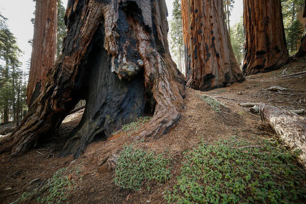
Burned, hollowed out base of a sequoia tree in Sequoia National Park
Burned, hollowed out base of a sequoia tree in Sequoia National Park
Burned, hollowed out base of a sequoia tree in Sequoia National Park

Pacific fisher trying to grab a chicken dinner from the bait box
USGS scientists are documenting the distribution of three mid-sized mammalian carnivores – or mesocarnivores –in the Klamath Network Parks using remote cameras and hair snares.
USGS scientists are documenting the distribution of three mid-sized mammalian carnivores – or mesocarnivores –in the Klamath Network Parks using remote cameras and hair snares.

Figure 1, Horn, et al. (2018)
Gradients of N deposition, S deposition, mean annual temperature, and mean annual precipitation across the conterminous U.S. Panels are the a) mean total N deposition from 2000–2012, b) mean total S deposition from 2000–2012, c) mean annual temperature from 2000–2014, and d) mean annual precipitation form 2000–2014.
Gradients of N deposition, S deposition, mean annual temperature, and mean annual precipitation across the conterminous U.S. Panels are the a) mean total N deposition from 2000–2012, b) mean total S deposition from 2000–2012, c) mean annual temperature from 2000–2014, and d) mean annual precipitation form 2000–2014.

Hurricane Michael cut deep into Panhandle dunes
A deeply eroded sand dune on the beach at Cape San Blas shows Hurricane Michael's impact on parts of the Florida Panhandle shoreline.
A deeply eroded sand dune on the beach at Cape San Blas shows Hurricane Michael's impact on parts of the Florida Panhandle shoreline.

Hurricane Michael destroyed many houses on Cape San Blas, Florida
A beach house in Cape San Blas, Florida destroyed by Hurricane Michael, which struck the Florida Panhandle as a Category Four storm Oct. 10, 2018.
A beach house in Cape San Blas, Florida destroyed by Hurricane Michael, which struck the Florida Panhandle as a Category Four storm Oct. 10, 2018.

Hillside at Whiskeytown National Recreation Area 2 Months After Fire
A landscape at Whiskeytown National Recreation Area 2 months after summer 2018's Carr Fire near Redding, California, where USGS WERC researchers are studying fire impacts, post-fire vegetation recovery, and post-fire erosion and debris flows.
A landscape at Whiskeytown National Recreation Area 2 months after summer 2018's Carr Fire near Redding, California, where USGS WERC researchers are studying fire impacts, post-fire vegetation recovery, and post-fire erosion and debris flows.

Hill at Whiskeytown National Recreation Area 2 Months After Fire
A landscape at Whiskeytown National Recreation Area 2 months after summer 2018's Carr Fire near Redding, California, where USGS WERC researchers are studying fire impacts, post-fire vegetation recovery, and post-fire erosion and debris flows.
A landscape at Whiskeytown National Recreation Area 2 months after summer 2018's Carr Fire near Redding, California, where USGS WERC researchers are studying fire impacts, post-fire vegetation recovery, and post-fire erosion and debris flows.

Landscape at Whiskeytown National Recreation Area 2 Months After Fire
A landscape at Whiskeytown National Recreation Area 2 months after summer 2018's Carr Fire near Redding, California, where USGS WERC researchers are studying fire impacts, post-fire vegetation recovery, and post-fire erosion and debris flows.
A landscape at Whiskeytown National Recreation Area 2 months after summer 2018's Carr Fire near Redding, California, where USGS WERC researchers are studying fire impacts, post-fire vegetation recovery, and post-fire erosion and debris flows.

Hillside at Whiskeytown National Recreation Area 2 Months After Fire
A landscape at Whiskeytown National Recreation Area 2 months after summer 2018's Carr Fire near Redding, California, where USGS WERC researchers are studying fire impacts, post-fire vegetation recovery, and post-fire erosion and debris flows.
A landscape at Whiskeytown National Recreation Area 2 months after summer 2018's Carr Fire near Redding, California, where USGS WERC researchers are studying fire impacts, post-fire vegetation recovery, and post-fire erosion and debris flows.

Looking at the ocean through the bottom of a plane
Looking through the belly port of a small airplane before an aerial photographic survey starts, Fall 2018.
The Seabird Studies Team at the USGS Western Ecological Research Center is conducting aerial photographic surveys of the ocean off central and southern California to create comprehensive maps of seabird and marine mammal distributions.

Fish Inn, the scientists' field station, before Hurricane Michael
For ten years, this yellow concrete block house in Cape San Blas, Florida, dubbed Fish Inn, was the seasonal office, laboratory and living quarters for a team of USGS sea turtle researchers during their field season from November till April.
For ten years, this yellow concrete block house in Cape San Blas, Florida, dubbed Fish Inn, was the seasonal office, laboratory and living quarters for a team of USGS sea turtle researchers during their field season from November till April.

Cyanobacterial bloom at Ash River Harbor near Voyageurs National Park
A cyanobacterial bloom in late fall at Ash River Harbor in Kabetogama Lake, Voyageurs National Park
A cyanobacterial bloom in late fall at Ash River Harbor in Kabetogama Lake, Voyageurs National Park

Cyanobacterial bloom at Ash River Harbor near Voyageurs National Park
Cyanobacterial bloom at Kabetogama Lake in Voyageurs National Park
Cyanobacterial bloom at Kabetogama Lake in Voyageurs National Park

Cyanobacterial bloom at Ash River Harbor near Voyageurs National Park
Cyanobacterial bloom in Kabetogama Lake with fall leaves in the background
Cyanobacterial bloom in Kabetogama Lake with fall leaves in the background

Glen Canyon Dam jet tubes releasing water for a high flow experiment
Glen Canyon Dam jet tubes releasing water into the Colorado River for a November 2018 high flow experiment. The increase in flow of the Colorado River downstream of the dam mobilizes sand at the bottom of the river and that sand rebuilds sandbars in Grand Canyon.
Glen Canyon Dam jet tubes releasing water into the Colorado River for a November 2018 high flow experiment. The increase in flow of the Colorado River downstream of the dam mobilizes sand at the bottom of the river and that sand rebuilds sandbars in Grand Canyon.

Remote Camera, 30-mile Camp (River MIe 30.7)
Remote Camera, 30-mile Camp (River MIe 30.7)
Remote Camera, 30-mile Camp (River MIe 30.7)