
A reef in the Florida Keys National Marine Sanctuary with little living coral and extensive bioerosion. Photo taken under research permit number FKNMS-2016-085-A1. Credit: USGS, Ilsa Kuffner.
Images
Explore water-related photography, imagery, and illustrations.
Filter Total Items: 2402

Erosion has taken a toll on this Keys coral
A reef in the Florida Keys National Marine Sanctuary with little living coral and extensive bioerosion. Photo taken under research permit number FKNMS-2016-085-A1. Credit: USGS, Ilsa Kuffner.

Impact of Hurricane Lane on Wailuku River
Two views from the Rainbow Falls overlook, downstream of the Wailuku River streamgage near Hilo, Hawaii. The image on the left shows a typical base flow of about 35 cubic feet per second (cfs). The image on the right shows the early impact of Hurricane Lane with a flow of about 26,000 cfs taken at 8:35 a.m. HST, August 23, 2018. This U.S.
Two views from the Rainbow Falls overlook, downstream of the Wailuku River streamgage near Hilo, Hawaii. The image on the left shows a typical base flow of about 35 cubic feet per second (cfs). The image on the right shows the early impact of Hurricane Lane with a flow of about 26,000 cfs taken at 8:35 a.m. HST, August 23, 2018. This U.S.
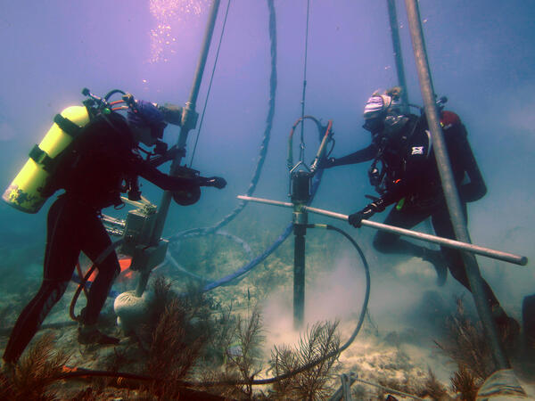
USGS scientists drill a coral-reef core in the Florida Keys
Research Oceanographer Lauren Toth and student volunteer Liz Whitcher drill a coral-reef core from a reef off Key West, Florida, in the Florida Keys National Marine Sanctuary. Photo taken under research permit FKNMS-2015-058. Credit: Anastasios Stathakopoulos, USGS.
Research Oceanographer Lauren Toth and student volunteer Liz Whitcher drill a coral-reef core from a reef off Key West, Florida, in the Florida Keys National Marine Sanctuary. Photo taken under research permit FKNMS-2015-058. Credit: Anastasios Stathakopoulos, USGS.

USGS Contract Scientist Taking Water Sample
Todd Preston, USGS contract scientist, collecting a surface-water sample from a Prairie Pothole wetland.
Todd Preston, USGS contract scientist, collecting a surface-water sample from a Prairie Pothole wetland.

Grand Canyon bank Erosion.
Comparing 2009 vs 2014 Bank surface after erosion, Grand Canyon AZ.
Comparing 2009 vs 2014 Bank surface after erosion, Grand Canyon AZ.

Sediment Deposit in the Grand Canyon, AZ
Sediment Deposit in the Grand Canyon, AZ
Sediment Deposit in the Grand Canyon, AZ

Cross section of deposited sediment in the Grand Canyon, AZ
Cross section of deposited sediment in the Grand Canyon, AZ
Cross section of deposited sediment in the Grand Canyon, AZ

A valley in the Grand Canyon, AZ
A valley in the Grand Canyon, AZ

USGS scientists on the Colorado River in the Grand Canyon, AZ
USGS scientists on the Colorado River in the Grand Canyon, AZ
USGS scientists on the Colorado River in the Grand Canyon, AZ

Using drones to study groundwater
Did you know that plants can help us understand what is happening underground? Studying plants in an area can sometimes provide information about soil conditions, water availability, and water quality.
Did you know that plants can help us understand what is happening underground? Studying plants in an area can sometimes provide information about soil conditions, water availability, and water quality.

Rainbow over a canyon in the Grand Canyon, AZ
Rainbow over a canyon in the Grand Canyon, AZ
Rainbow over a canyon in the Grand Canyon, AZ

Using drones to study groundwater
Did you know that plants can sometimes help us understand what is happening underground? Studying plants in an area can provide information about soil conditions, water availability, and water quality.
Did you know that plants can sometimes help us understand what is happening underground? Studying plants in an area can provide information about soil conditions, water availability, and water quality.

Water quality at the Salmon River
Installing dissolved oxygen sensors at the Salmon River near East Hampton, Connecticut
Installing dissolved oxygen sensors at the Salmon River near East Hampton, Connecticut

Hydrologic technician making a streamflow measurement
Hydrologic technician making a streamflow measurement using a FlowTracker ADV in a river.
Hydrologic technician making a streamflow measurement using a FlowTracker ADV in a river.

Drone image of stream
Aerial image of stream and wetlands collected using a small unoccupied aicraft (sUAS) or drone at Ashville Bridge Creek, Back Bay National Wildlife Refuge (NWR), Virginia Beach, Virginia.
Aerial image of stream and wetlands collected using a small unoccupied aicraft (sUAS) or drone at Ashville Bridge Creek, Back Bay National Wildlife Refuge (NWR), Virginia Beach, Virginia.

Water Sampling on the Floodplain of the Missouri River
Water Sampling on the Floodplain of the Missouri River
Water Sampling on the Floodplain of the Missouri River

Aerial Image of the Deposits of the 2011 Missouri River Flood
Aerial Image of the effects of the 2011 Missouri River Flood
Aerial Image of the effects of the 2011 Missouri River Flood

Arial Image of the 2011 Missouri River Flood
Arial Image of the 2011 Missouri River Flood
Arial Image of the 2011 Missouri River Flood

Like many Keys corals, this one has no new growth
A modern coral reef in Dry Tortugas National Park. There is little living coral and high rates of bioerosion. Photo taken under research permit number DRTO-2018-SCI-0005. Credit: Lauren Toth, USGS
A modern coral reef in Dry Tortugas National Park. There is little living coral and high rates of bioerosion. Photo taken under research permit number DRTO-2018-SCI-0005. Credit: Lauren Toth, USGS

Map of the U.S. by state, showing total water withdrawals, 2015
Map of the U.S. by state, showing total water withdrawals, 2015
Map of the U.S. by state, showing total water withdrawals, 2015

Real-time flow meter on an Arkansas irrigation well
Real-time flow meter installed on a center-pivot irrigation well in Mississippi County, Arkansas as part of a cooperative project conducted between USGS and the Arkansas Natural Resources Commission. The meter will measure water use for irrigation, providing data which will help improve water-use information in other locations as well.
Real-time flow meter installed on a center-pivot irrigation well in Mississippi County, Arkansas as part of a cooperative project conducted between USGS and the Arkansas Natural Resources Commission. The meter will measure water use for irrigation, providing data which will help improve water-use information in other locations as well.