
Dry conditions at cattle water sources in western Colorado.
Images
Images described and linked on this webpage come from a wide variety of USGS science activities and presentations performed by USGS Science Center staff members in the Region 7: Upper Colorado Basin. A search tool is provided to narrow the number of image files shown.
Filter Total Items: 495

Dry conditions at cattle water sources in western Colorado
Dry conditions at cattle water sources in western Colorado.

USGS personnel measure flood waters on Wind River, WY
USGS hydrographer Jerrod Wheeler (in cablecar) measures flood flows right before the gagehouse washes away.
06225500 Wind River near Crowheart, WY: Jul 01 2011; 13,900 ft3/s
USGS hydrographer Jerrod Wheeler (in cablecar) measures flood flows right before the gagehouse washes away.
06225500 Wind River near Crowheart, WY: Jul 01 2011; 13,900 ft3/s

Flood Waters Take USGS Streamgage Wind River near Crowheart, WY
Gagehouse at 06225500 Wind River near Crowheart WY right before it washed away.
Jul 01 2011; 13,900 ft3/s
Gagehouse at 06225500 Wind River near Crowheart WY right before it washed away.
Jul 01 2011; 13,900 ft3/s

Flooding in Northwest Colorado
High floodwaters partially submerge a USGS streamgaging station in Slater Fork, CO.
High floodwaters partially submerge a USGS streamgaging station in Slater Fork, CO.

Flooding in Northwest Colorado
High floodwaters on the Elk River upstream of Routt County Road 42 near Milner, CO.
High floodwaters on the Elk River upstream of Routt County Road 42 near Milner, CO.

Flooding in Northwest Colorado
High floodwaters on the Elk River upstream of Routt County Road 42 near Milner, CO
High floodwaters on the Elk River upstream of Routt County Road 42 near Milner, CO

Flooding in Northwest Colorado
A roadway is broken down due to high streamflow near Slater, CO. A USGS streamgage can be seen next to the road.
A roadway is broken down due to high streamflow near Slater, CO. A USGS streamgage can be seen next to the road.

Flooding in Northwest Colorado
Floodwaters partially submerge a USGS streamgage station near Slater, CO.
Floodwaters partially submerge a USGS streamgage station near Slater, CO.

2011 Great Salt Lake Breach at Lakeside, Utah
Water flowing through the Great Salt Lake breach in 2011, when lake levels were high due to above average snowfall in the Wasatch and Uinta Mountains. The Great Salt Lake breach is an area that allows water to travel between the southern and northern parts of the lake.
Water flowing through the Great Salt Lake breach in 2011, when lake levels were high due to above average snowfall in the Wasatch and Uinta Mountains. The Great Salt Lake breach is an area that allows water to travel between the southern and northern parts of the lake.

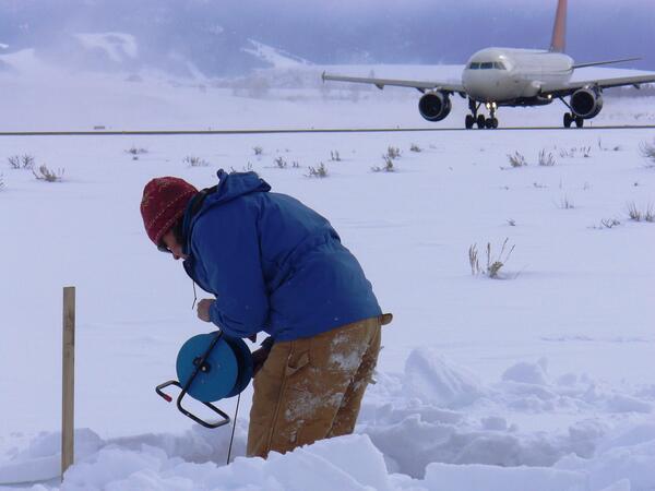
Collecting a groundwater sample using a mobile laboratory at Jackson H
Collecting a groundwater sample using a mobile laboratory at Jackson Hole Airport
Collecting a groundwater sample using a mobile laboratory at Jackson Hole Airport

View of Jackson Hole Airport and the Teton Range
View of Jackson Hole Airport and the Teton Range
View of Jackson Hole Airport and the Teton Range
Taking a water-level measurement in a monitoring well at Jackson Hole
Taking a water-level measurement in a monitoring well at Jackson Hole Airport.
Taking a water-level measurement in a monitoring well at Jackson Hole Airport.

Lamar Valley, Yellowstone National Park.
Lamar Valley, Yellowstone National Park.
Lamar Valley, Yellowstone National Park.

Invasive brown treesnake
Brown treesnakes were a major contributor to the loss of nine of 11 native forest birds on Guam.
Brown treesnakes were a major contributor to the loss of nine of 11 native forest birds on Guam.

Ranchlands, Utah and Idaho
Roadsides, ranchlands, and mountains.
Roadsides, ranchlands, and mountains.

Ranchlands, Utah and Idaho
Roadsides, ranchlands, and mountains.
Roadsides, ranchlands, and mountains.

Rainstorms can be localized or widespread.
A localized heavy summer rainstorm in Colorado.
A localized heavy summer rainstorm in Colorado.

Collecting habitat data at 06324970
Collecting habitat data at 06324970
Collecting habitat data at 06324970

Preparing sample for macroinvertebrate analysis
Preparing sample for macroinvertebrate analysis
Preparing sample for macroinvertebrate analysis

The last sheath-tailed bat photo
This photo of a Pacific sheath-tailed bat is the last good photo of this bat from Aguiguan in existence.
This photo of a Pacific sheath-tailed bat is the last good photo of this bat from Aguiguan in existence.

Measuring water level in streambank piezometer nr Wind Riv at Kinnear
Measuring water level in streambank piezometer nr Wind River at Kinnear
Measuring water level in streambank piezometer nr Wind River at Kinnear