
Bob Brandle and Cory Stevens of the USGS Colorado Water Science Center record streamflow and water level measurements for the flooded St. Vrain River near Longmont, Colo. The river is one of many that flooded during a significant September 2013 rain event along Colorado's Front Range, damaging or destroying several USGS streamgages.
Images
Images described and linked on this webpage come from a wide variety of USGS science activities and presentations performed by USGS Science Center staff members in the Region 7: Upper Colorado Basin. A search tool is provided to narrow the number of image files shown.
Filter Total Items: 495

USGS Field Crew On-Site During the Sept 2013 Colorado Flood
Bob Brandle and Cory Stevens of the USGS Colorado Water Science Center record streamflow and water level measurements for the flooded St. Vrain River near Longmont, Colo. The river is one of many that flooded during a significant September 2013 rain event along Colorado's Front Range, damaging or destroying several USGS streamgages.

Bear scat.
When looking for a place to set up a capture location, biologists look for existing bear sign such as scratches on trees and bear scat. Sometimes traps are set in areas that have no obvious bear sign to determine if indeed bears are present.
When looking for a place to set up a capture location, biologists look for existing bear sign such as scratches on trees and bear scat. Sometimes traps are set in areas that have no obvious bear sign to determine if indeed bears are present.

Bear River, Utah
Looking northeast along the Bear River Duck Club Canal toward the Wellsville Mountains.
Looking northeast along the Bear River Duck Club Canal toward the Wellsville Mountains.

Wastewater Disposal Facility in Colorado
Oilfield waste arrives by tanker truck at a wastewater disposal facility near Platteville, Colo. After removal of solids and oil, the wastewater is injected into a deep well for permanent storage underground. This disposal process has the potential to trigger earthquakes, but very few wastewater disposal wells produce earthquakes.
Oilfield waste arrives by tanker truck at a wastewater disposal facility near Platteville, Colo. After removal of solids and oil, the wastewater is injected into a deep well for permanent storage underground. This disposal process has the potential to trigger earthquakes, but very few wastewater disposal wells produce earthquakes.

USGS scientist collecting a water sample from Boulder Creek, Colorado.
A USGS scientist collecting a water-quality sample from Boulder Creek, Colorado.
A USGS scientist collecting a water-quality sample from Boulder Creek, Colorado.

Elk on a feedground in Wyoming.
Elk on a feedground in Wyoming.
Elk on a feedground in Wyoming.

Bacteria contained in filter chambers
Bacteria contained in filter chambers placed in downgradient observation wells were exposed to sulfamethoxazole for 30 days as it traveled past the wells
Bacteria contained in filter chambers placed in downgradient observation wells were exposed to sulfamethoxazole for 30 days as it traveled past the wells

Bacteria contained in filter chambers
Microbial-Contaminant Interactions Laboratory — Boulder, Colorado. Bacteria contained in filter chambers placed in downgradient observation wells were exposed to sulfamethoxazole for 30 days as it traveled past the wells.
Microbial-Contaminant Interactions Laboratory — Boulder, Colorado. Bacteria contained in filter chambers placed in downgradient observation wells were exposed to sulfamethoxazole for 30 days as it traveled past the wells.

Prairie dog and SPV bait
In this image, a Gunnison prairie dog eats a bait laden with the sylvatic plague vaccine. Prairie dogs in the wild are less likely to succumb to plague after they ingest peanut-butter-flavored bait that contains a vaccine against the disease.
In this image, a Gunnison prairie dog eats a bait laden with the sylvatic plague vaccine. Prairie dogs in the wild are less likely to succumb to plague after they ingest peanut-butter-flavored bait that contains a vaccine against the disease.

Utah Tribal Coop
In the stream is Martel Fisher (USGS) and Bart Powaukee (Coordinator Ute Indian Tribe Water Quality Department) and some of the Ute Tribe Water Quality Department employees.
In the stream is Martel Fisher (USGS) and Bart Powaukee (Coordinator Ute Indian Tribe Water Quality Department) and some of the Ute Tribe Water Quality Department employees.

map of historic and current sage-grouse range in 2000
Map of historic and current sage-grouse range in 2000, provided as a download from the old USGS Sagemap website.
Map of historic and current sage-grouse range in 2000, provided as a download from the old USGS Sagemap website.

Red Mountain, CO Hydrothermal Alteration
Photo showing intense acid-sulfate hydrothermal alteration on Red Mountain No. 2, Silverton CO. View is looking to the west across Corkscrew Gulch.
Photo showing intense acid-sulfate hydrothermal alteration on Red Mountain No. 2, Silverton CO. View is looking to the west across Corkscrew Gulch.

San Miguel Site Map, New Mexico Water Science Center
Canadian escarpment rising above the plains, northeastern San Miguel County, NMWSC
Canadian escarpment rising above the plains, northeastern San Miguel County, NMWSC
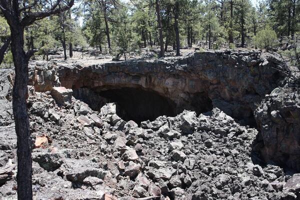
Lava tube opening/possible bat roost with pine forest above.
Opening of a large lava tube at El Malpais National Monument in western New Mexico and likely roost for bats, 2011.
Opening of a large lava tube at El Malpais National Monument in western New Mexico and likely roost for bats, 2011.

View from sandstone bluff overlooking extinct lava flows at El Malpais
View from sandstone bluff overlooking extinct lava flows at El Malpais National Monument, New Mexico.
View from sandstone bluff overlooking extinct lava flows at El Malpais National Monument, New Mexico.

Elk in Beartooth Mountains, WY
Elk in the Beartooth Mountains, Wyoming. The USGS and partners study the effects of climate change on the Greater Yellowstone Ecosystem.
Elk in the Beartooth Mountains, Wyoming. The USGS and partners study the effects of climate change on the Greater Yellowstone Ecosystem.

Great Salt Lake
This is a false-color-composite satellite image of Great Salt Lake, Nov 2011. The vegetation appears red.
This is a false-color-composite satellite image of Great Salt Lake, Nov 2011. The vegetation appears red.

Measuring streamflow using ADCP, Fish Creek
Measuring streamflow using ADCP, Fish Creek
Measuring streamflow using ADCP, Fish Creek

Trees Killed by the 2011 Las Conchas Fire in New Mexico
Extensive, contiguous mortality of piñon pine, ponderosa pine, and Douglas-fir trees, killed in the first afternoon and evening of the 2011 Las Conchas Fire in the Jemez Mountains, New Mexico. Forest drought stress is highly correlated with mortality from poor growth, bark beetle outbreaks, and high-severity fire.
Extensive, contiguous mortality of piñon pine, ponderosa pine, and Douglas-fir trees, killed in the first afternoon and evening of the 2011 Las Conchas Fire in the Jemez Mountains, New Mexico. Forest drought stress is highly correlated with mortality from poor growth, bark beetle outbreaks, and high-severity fire.

Cattle walking across biological soil crusts in southeastern Utah
Cattle walking across biological soil crusts in southeastern Utah.
Cattle walking across biological soil crusts in southeastern Utah.