
EnviSense data-logger/transmitter developed by Carnegie Mellon University actively deployed with stage sensor at USGS streamgage at Beale Air Force Base near Marysville, California.
Images
Images described and linked on this webpage come from a wide variety of USGS science activities and presentations performed by USGS Science Center staff members in the Region 10: California-Great Basin. A search tool is provided to narrow the number of image files shown.
Filter Total Items: 76

EnviSense with stage sensor at USGS streamgage at Beale Air Force Base near Marysville CA
EnviSense data-logger/transmitter developed by Carnegie Mellon University actively deployed with stage sensor at USGS streamgage at Beale Air Force Base near Marysville, California.

Adult Lahontan cutthroat trout
Lahontan cutthroat trout (Oncorhynchus clarkii henshawi) is a federally listed threatened species. Ninety-seven percent of their range are small headwater streams in the Great Basin of North America.
Lahontan cutthroat trout (Oncorhynchus clarkii henshawi) is a federally listed threatened species. Ninety-seven percent of their range are small headwater streams in the Great Basin of North America.

BisonCore project equipment identifying marker
USGS National Innovation Center's UAS Research Center BisonCore Project Equipment Identifying Marker
USGS National Innovation Center's UAS Research Center BisonCore Project Equipment Identifying Marker

Wind turbines in California
Wind turbines at the San Gorgonio Pass Wind Resource Area north of Palm Springs in California.
Wind turbines at the San Gorgonio Pass Wind Resource Area north of Palm Springs in California.

Dragonfly Mercury Project specimen collection in Glacier NP
Researchers instruct volunteers on how to collect dragonfly larvae in Glacier NP as a part of the Dragonfly Mercury Project.
Researchers instruct volunteers on how to collect dragonfly larvae in Glacier NP as a part of the Dragonfly Mercury Project.

Debris flow after the 2003 Old Gran Prix fire
Damage from a major post-wildfire landslide that occurred on 25 December 2003 near Devore, San Bernardino County as a result of the Old/Grand Prix fires that ran through the San Bernardino Mountains.
Damage from a major post-wildfire landslide that occurred on 25 December 2003 near Devore, San Bernardino County as a result of the Old/Grand Prix fires that ran through the San Bernardino Mountains.

Home damaged by post-wildfire debris flow in Montecito, CA.
Damage from a major post-wildfire landslide that occurred on 9 January 2018 near Montecito, Santa Barbara County as a result of the 2017 Thomas Fire.
Damage from a major post-wildfire landslide that occurred on 9 January 2018 near Montecito, Santa Barbara County as a result of the 2017 Thomas Fire.

Williamson River below the Sprague River in Chiloquin, OR.
This is a view of a USGS surface water stream gage that contains equipment to monitor discharge at the Williamson River below the Sprague Ruver in Chiloquin, Oregon. The gage house contains a historic stilling well and a device that records the level of water. It also has a water temerature sensor and a turbidimeter.
This is a view of a USGS surface water stream gage that contains equipment to monitor discharge at the Williamson River below the Sprague Ruver in Chiloquin, Oregon. The gage house contains a historic stilling well and a device that records the level of water. It also has a water temerature sensor and a turbidimeter.

Measuring wildlife mortality
Scientists collect carcasses at a wind energy facility to estimate total wildlife mortality at a site.
Scientists collect carcasses at a wind energy facility to estimate total wildlife mortality at a site.
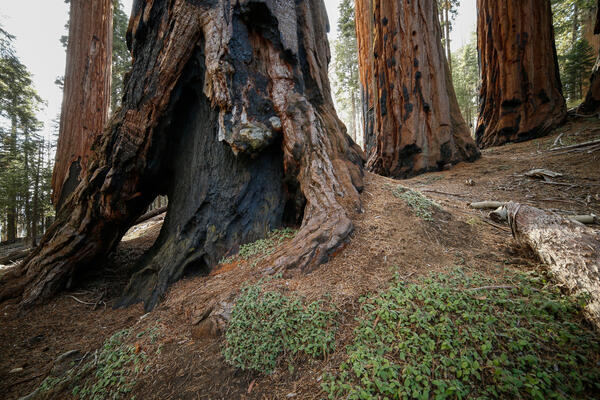
Burned, hollowed out base of a sequoia tree in Sequoia National Park
Burned, hollowed out base of a sequoia tree in Sequoia National Park
Burned, hollowed out base of a sequoia tree in Sequoia National Park

RestoreNet outplanted seedlings (left) v. direct seeding with soil surface treatments (right)
Left: RestoreNet outplant trials with greenhouse-grown seedlings planted into the field, Right: RestoreNet direct seeding trials with seeds combined with soil surface modifications including ConMod artificial nurse plants, mulch, and soil pits. Photos by Katie Laushman (USGS).
Left: RestoreNet outplant trials with greenhouse-grown seedlings planted into the field, Right: RestoreNet direct seeding trials with seeds combined with soil surface modifications including ConMod artificial nurse plants, mulch, and soil pits. Photos by Katie Laushman (USGS).
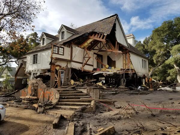
Montecito home damaged by post-wildfire debrisflow.
Damage from a major post-wildfire landslide that occurred on 9 January 2018 near Montecito, Santa Barbara County as a result of the 2017 Thomas Fire.
Damage from a major post-wildfire landslide that occurred on 9 January 2018 near Montecito, Santa Barbara County as a result of the 2017 Thomas Fire.

Christie Hegermiller geared up for beach elevation survey
Christie gears up to survey beach elevation in Santa Cruz, CA with a precise and accurate GPS unit mounted to her backpack. The GPS unit on her backpack communicates with a nearby "base station" to minimize errors in location.
Christie gears up to survey beach elevation in Santa Cruz, CA with a precise and accurate GPS unit mounted to her backpack. The GPS unit on her backpack communicates with a nearby "base station" to minimize errors in location.