
Decreasing water levels in the southern arm of the Great Salt Lake expose microbialite communities that are normally underwater.
Images
Explore our planet through photography and imagery, including climate change and water all the way back to the 1800s when the USGS was surveying the country by horse and buggy.
Filter Total Items: 21547

Great Salt Lake May Reach Historic Low Soon
Decreasing water levels in the southern arm of the Great Salt Lake expose microbialite communities that are normally underwater.

Little Snake River near Dixon low streamflow
Little Snake River near Dixon low streamflow
Little Snake River near Dixon low streamflow

Low Flows at Little Snake River near Dixon streamgage
Low Flows at Little Snake River near Dixon streamgage
Low Flows at Little Snake River near Dixon streamgage

Salt lick and device to exclude wildlife from access to minerals
Orange and black excluder device (left) will contain minerals, but intended to allow livestock access while excluding wildlife. Mineral block to the right of excluder device.
Orange and black excluder device (left) will contain minerals, but intended to allow livestock access while excluding wildlife. Mineral block to the right of excluder device.
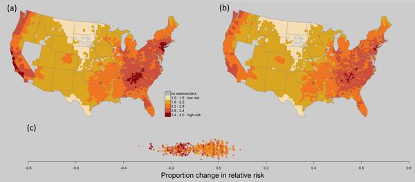
Maps of Bsal risk in the U.S. comparing pre- and post- action risk
Relative risk maps of combined Bsal risk, comparing (a) pre-action risk (2010–2015), to (b) risk after implementation of surveillance and of importation restrictions on over 200 salamander species. Relative risk scores were scaled to 2010–2015. (c) Change in relative risk score per county as proportion of pre-action risk.
Relative risk maps of combined Bsal risk, comparing (a) pre-action risk (2010–2015), to (b) risk after implementation of surveillance and of importation restrictions on over 200 salamander species. Relative risk scores were scaled to 2010–2015. (c) Change in relative risk score per county as proportion of pre-action risk.

Taking a water sample in Green River
Photo Contest Winner | July 2021 | Honorable Mention 1
Taking a water sample in Green River
Photo Contest Winner | July 2021 | Honorable Mention 1
Taking a water sample in Green River

View of Halema‘uma‘u at Kīlauea summit - July 2 2021
A view looking north into Halema‘uma‘u on July 2, 2021. Although eruptive activity has paused at the summit of Kīlauea, HVO geologists still monitor the lava lake and summit area regularly. Lava lake surface depths remain the same over the past few weeks.
A view looking north into Halema‘uma‘u on July 2, 2021. Although eruptive activity has paused at the summit of Kīlauea, HVO geologists still monitor the lava lake and summit area regularly. Lava lake surface depths remain the same over the past few weeks.

Hebgen Lake recent seismicity and 1959 deformation
Epicenters of 6,188 earthquakes in the Hebgen Lake region since 1990 determined by the University of Utah Seismograph Stations and the Montana Bureau of Mines and Geology. All epicenters have horizontal uncertainties of 1.0 km or less.
Epicenters of 6,188 earthquakes in the Hebgen Lake region since 1990 determined by the University of Utah Seismograph Stations and the Montana Bureau of Mines and Geology. All epicenters have horizontal uncertainties of 1.0 km or less.

High resolution mass spectrometer used for chemical analyses
High resolution mass spectrometer at the USGS Eastern Ecological Science Center. Any display of trade, firm, or product names is for descriptive purposes only and does not imply endorsement by the U.S. Government.
High resolution mass spectrometer at the USGS Eastern Ecological Science Center. Any display of trade, firm, or product names is for descriptive purposes only and does not imply endorsement by the U.S. Government.

Lees Ferry streamgage and cableway on the Colorado River, Arizona
Lees Ferry streamgage and cableway downstream on the Colorado River, Arizona
Lees Ferry streamgage and cableway downstream on the Colorado River, Arizona

Photomicrograph from a raccoon found sick and euthanized in Texas
Photomicrograph from a raccoon (Procyon lotor) found sick and euthanized in Texas, US. (A) A cluster of schistosome ova are present in the pancreas. Ova are thin-shelled and are not operculated. Each viable egg contains a miracidium (arrows). The ova are surrounded by infiltrates of eosinophils, macrophages, and lymphocytes. H&E stain.
Photomicrograph from a raccoon (Procyon lotor) found sick and euthanized in Texas, US. (A) A cluster of schistosome ova are present in the pancreas. Ova are thin-shelled and are not operculated. Each viable egg contains a miracidium (arrows). The ova are surrounded by infiltrates of eosinophils, macrophages, and lymphocytes. H&E stain.

Pre-construction monitoring of vegetation for the Gemini Solar Array
The United States is developing renewable energy resources, especially solar, at a rapid rate.
The United States is developing renewable energy resources, especially solar, at a rapid rate.

Scientist standing near a high resolution mass spectrometer
USGS scientist standing near the high-resolution mass spectrometer at the U.S. Geological Survey Eastern Ecological Science Center. The instrument will be used for analyses of PFAS in plasma and tissue samples. Any display of trade, firm, or product names is for descriptive purposes only and does not imply endorsement by the U.S. Government.
USGS scientist standing near the high-resolution mass spectrometer at the U.S. Geological Survey Eastern Ecological Science Center. The instrument will be used for analyses of PFAS in plasma and tissue samples. Any display of trade, firm, or product names is for descriptive purposes only and does not imply endorsement by the U.S. Government.

Volcanoes in Canada?
At left, a map of select recent volcanoes and volcanic areas in Canada (volcano location data from: Global GIS: volcanoes of the world; volcano basic data. [Shapefile]. American Geological Institute.
At left, a map of select recent volcanoes and volcanic areas in Canada (volcano location data from: Global GIS: volcanoes of the world; volcano basic data. [Shapefile]. American Geological Institute.

Herring River Estuary, Cape Cod, MA
Image of a tidally restricted wetland in the Herring River Estuary, Cape Cod, MA
Image of a tidally restricted wetland in the Herring River Estuary, Cape Cod, MA

Debris Flows Across I-70 in Glenwood Canyon, Colorado
Ground level view of debris covering the eastbound lane of I-70 following the June 26-27, 2021, storms. The green sign in the background indicating Milepost 120 is mostly buried by mud.
Ground level view of debris covering the eastbound lane of I-70 following the June 26-27, 2021, storms. The green sign in the background indicating Milepost 120 is mostly buried by mud.

Paper mill reservoir in the Black River Valley
Photo Contest Winner | July 2021 | Where We Work
Paper mill reservoir in the Black River Valley, western Adirondacks, near Lyonsdale, New York
Photo Contest Winner | July 2021 | Where We Work
Paper mill reservoir in the Black River Valley, western Adirondacks, near Lyonsdale, New York

Kīlauea summit on June 25, 2021
Blue-tinged gases are seen above the lava lake in Halema‘uma‘u crater in this image taken from the southwest rim on June 25, 2021, at 12:37 p.m. HST.
Blue-tinged gases are seen above the lava lake in Halema‘uma‘u crater in this image taken from the southwest rim on June 25, 2021, at 12:37 p.m. HST.

Mark Jones taking a measurement in Danville, Pennsylvania
Photo Contest Winner | July 2021 | Honorable Mention 2
Mark Jones taking a measurement in Danville, Pennsylvania
Photo Contest Winner | July 2021 | Honorable Mention 2
Mark Jones taking a measurement in Danville, Pennsylvania

LSPIV Install on the Hudson River, New York
LSPIV Install on the Hudson River, New York
LSPIV Install on the Hudson River, New York

Jean Self-Trail and Laurel Bybell in Prince Georges County, Maryland
Photo Contest Winner | July 2021 | People
Jean Self-Trail and Laurel Bybell in Prince Georges County, Maryland
Photo Contest Winner | July 2021 | People
Jean Self-Trail and Laurel Bybell in Prince Georges County, Maryland