
Damage from a major post-wildfire landslide that occurred on 9 January 2018 near Montecito, Santa Barbara County as a result of the 2017 Thomas Fire.
Images
Images intro.
Filter Total Items: 66

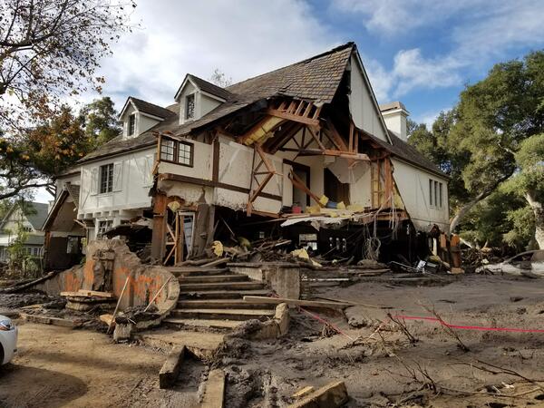
Home damaged by post-wildfire debris flow in Montecito, CA.
Damage from a major post-wildfire landslide that occurred on 9 January 2018 near Montecito, Santa Barbara County as a result of the 2017 Thomas Fire.

Debris flow after the 2003 Old Gran Prix fire
Damage from a major post-wildfire landslide that occurred on 25 December 2003 near Devore, San Bernardino County as a result of the Old/Grand Prix fires that ran through the San Bernardino Mountains.
Damage from a major post-wildfire landslide that occurred on 25 December 2003 near Devore, San Bernardino County as a result of the Old/Grand Prix fires that ran through the San Bernardino Mountains.

Thermal imaging for fire research
Use of thermal imaging helps researchers to understand the relationship of fuels and fire effects, Valles Caldera National Preserve, New Mexico, 2019.
Use of thermal imaging helps researchers to understand the relationship of fuels and fire effects, Valles Caldera National Preserve, New Mexico, 2019.

Hillside at Whiskeytown National Recreation Area 9 Months After Fire
Vegetation has begun to regrow in Whiskeytown National Recreation Area 9 months after summer 2018's Carr Fire near Redding, California, where USGS WERC researchers are studying fire impacts, post-fire vegetation recovery, and post-fire erosion and debris flows.
Vegetation has begun to regrow in Whiskeytown National Recreation Area 9 months after summer 2018's Carr Fire near Redding, California, where USGS WERC researchers are studying fire impacts, post-fire vegetation recovery, and post-fire erosion and debris flows.

Hill at Whiskeytown National Recreation Area 9 Months After Fire
Vegetation has begun to regrow in Whiskeytown National Recreation Area 9 months after summer 2018's Carr Fire near Redding, California, where USGS WERC researchers are studying fire impacts, post-fire vegetation recovery, and post-fire erosion and debris flows.
Vegetation has begun to regrow in Whiskeytown National Recreation Area 9 months after summer 2018's Carr Fire near Redding, California, where USGS WERC researchers are studying fire impacts, post-fire vegetation recovery, and post-fire erosion and debris flows.

Landscape at Whiskeytown National Recreation Area 9 Months After Fire
Vegetation has begun to regrow in Whiskeytown National Recreation Area 9 months after summer 2018's Carr Fire near Redding, California, where USGS WERC researchers are studying fire impacts, post-fire vegetation recovery, and post-fire erosion and debris flows.
Vegetation has begun to regrow in Whiskeytown National Recreation Area 9 months after summer 2018's Carr Fire near Redding, California, where USGS WERC researchers are studying fire impacts, post-fire vegetation recovery, and post-fire erosion and debris flows.

Hillside at Whiskeytown National Recreation Area 2 Months After Fire
A landscape at Whiskeytown National Recreation Area 2 months after summer 2018's Carr Fire near Redding, California, where USGS WERC researchers are studying fire impacts, post-fire vegetation recovery, and post-fire erosion and debris flows.
A landscape at Whiskeytown National Recreation Area 2 months after summer 2018's Carr Fire near Redding, California, where USGS WERC researchers are studying fire impacts, post-fire vegetation recovery, and post-fire erosion and debris flows.

Hill at Whiskeytown National Recreation Area 2 Months After Fire
A landscape at Whiskeytown National Recreation Area 2 months after summer 2018's Carr Fire near Redding, California, where USGS WERC researchers are studying fire impacts, post-fire vegetation recovery, and post-fire erosion and debris flows.
A landscape at Whiskeytown National Recreation Area 2 months after summer 2018's Carr Fire near Redding, California, where USGS WERC researchers are studying fire impacts, post-fire vegetation recovery, and post-fire erosion and debris flows.

Landscape at Whiskeytown National Recreation Area 2 Months After Fire
A landscape at Whiskeytown National Recreation Area 2 months after summer 2018's Carr Fire near Redding, California, where USGS WERC researchers are studying fire impacts, post-fire vegetation recovery, and post-fire erosion and debris flows.
A landscape at Whiskeytown National Recreation Area 2 months after summer 2018's Carr Fire near Redding, California, where USGS WERC researchers are studying fire impacts, post-fire vegetation recovery, and post-fire erosion and debris flows.

Hillside at Whiskeytown National Recreation Area 2 Months After Fire
A landscape at Whiskeytown National Recreation Area 2 months after summer 2018's Carr Fire near Redding, California, where USGS WERC researchers are studying fire impacts, post-fire vegetation recovery, and post-fire erosion and debris flows.
A landscape at Whiskeytown National Recreation Area 2 months after summer 2018's Carr Fire near Redding, California, where USGS WERC researchers are studying fire impacts, post-fire vegetation recovery, and post-fire erosion and debris flows.

Collecting soil and charcoal sample after a wildfire
Brett Tipple (University of California, Santa Cruz) collects a sample of charcoal and soil adjacent to a gully forming on a hillslope above Sonoma Creek, which was burned by the Nuns wildfire in October 2017.
Brett Tipple (University of California, Santa Cruz) collects a sample of charcoal and soil adjacent to a gully forming on a hillslope above Sonoma Creek, which was burned by the Nuns wildfire in October 2017.
Montecito home damaged by post-wildfire debrisflow.
Damage from a major post-wildfire landslide that occurred on 9 January 2018 near Montecito, Santa Barbara County as a result of the 2017 Thomas Fire.
Damage from a major post-wildfire landslide that occurred on 9 January 2018 near Montecito, Santa Barbara County as a result of the 2017 Thomas Fire.

Soil Burn Severity Map for Eagle Creek Fire, Oregon 2017
Soil burn severity for the Eagle Creek Fire, Oregon (2017). Soil burn severity is used for postfire assessments to determine flash flooding and postfire debris flow potential for a recently burned area.
Soil burn severity for the Eagle Creek Fire, Oregon (2017). Soil burn severity is used for postfire assessments to determine flash flooding and postfire debris flow potential for a recently burned area.

Experimental herbicide treatment plot in Idaho
The Wildcat experimental treatment site in southwest Idaho at the base of the Owyhee Mountains. The brown square was treated with pre-emergent herbicide and is free of cheatgrass, a few native perennial bunchgrasses were able to establish. This image was taken the first Spring after treatment.
The Wildcat experimental treatment site in southwest Idaho at the base of the Owyhee Mountains. The brown square was treated with pre-emergent herbicide and is free of cheatgrass, a few native perennial bunchgrasses were able to establish. This image was taken the first Spring after treatment.

LANDFIRE Existing Vegetation Type
LANDFIRE's Existing Vegetation Type layer from the Data Distribution Site.
LANDFIRE's Existing Vegetation Type layer from the Data Distribution Site.

El Dorado National Forest after the 2014 King Fire
The 2014 King Fire burned 97,717 acres in the El Dorado National Forest and on private timberlands. The fires in these burn areas reduce the forest canopy, exposing snowpack to direct sunlight. This increases the rate of snowmelt and evaporation, impacting runoff and groundwater replenishment.
The 2014 King Fire burned 97,717 acres in the El Dorado National Forest and on private timberlands. The fires in these burn areas reduce the forest canopy, exposing snowpack to direct sunlight. This increases the rate of snowmelt and evaporation, impacting runoff and groundwater replenishment.

A fire burns along the ground in a ponderosa pine forest, New Mexico
Prescribed fires, such as this one, are used by land managers to restore ponderosa pine forests to more resilient conditions. We are fortunate to be able to occasionally participate in such burns because we are co-located with land managers.
Prescribed fires, such as this one, are used by land managers to restore ponderosa pine forests to more resilient conditions. We are fortunate to be able to occasionally participate in such burns because we are co-located with land managers.

Vegetation monitoring in the area burned by the Soda Fire, 2015
USGS scientists monitor BLM efforts to restore vegetation in the area burned byt he 2015 Soda Fire in southwest Idaho and southeast Oregon sagebrush-steppe.
USGS scientists monitor BLM efforts to restore vegetation in the area burned byt he 2015 Soda Fire in southwest Idaho and southeast Oregon sagebrush-steppe.

Las Conchas Fire, NM Water Science Center
This is a photograph of the Las Conchas Fire, USGS - New Mexico Water Science Center
This is a photograph of the Las Conchas Fire, USGS - New Mexico Water Science Center

Assessing the severity of the Funny River fire on the Kenai Peninsula
Pre- and post-fire measurements of fire effects help ecologists, fire scientists, and managers determine how the severity of wildfires affects plants, animal habitat, and ecosystem services.
Pre- and post-fire measurements of fire effects help ecologists, fire scientists, and managers determine how the severity of wildfires affects plants, animal habitat, and ecosystem services.