
Damage from a major post-wildfire landslide that occurred on 25 December 2003 near Devore, San Bernardino County as a result of the Old/Grand Prix fires that ran through the San Bernardino Mountains.
Images
Images described and linked on this webpage come from a wide variety of USGS science activities and presentations performed by USGS Science Center staff members in the Region 10: California-Great Basin. A search tool is provided to narrow the number of image files shown.
Filter Total Items: 91

Debris flow after the 2003 Old Gran Prix fire
Damage from a major post-wildfire landslide that occurred on 25 December 2003 near Devore, San Bernardino County as a result of the Old/Grand Prix fires that ran through the San Bernardino Mountains.

Williamson River below the Sprague River in Chiloquin, OR.
This is a view of a USGS surface water stream gage that contains equipment to monitor discharge at the Williamson River below the Sprague Ruver in Chiloquin, Oregon. The gage house contains a historic stilling well and a device that records the level of water. It also has a water temerature sensor and a turbidimeter.
This is a view of a USGS surface water stream gage that contains equipment to monitor discharge at the Williamson River below the Sprague Ruver in Chiloquin, Oregon. The gage house contains a historic stilling well and a device that records the level of water. It also has a water temerature sensor and a turbidimeter.

Measuring wildlife mortality
Scientists collect carcasses at a wind energy facility to estimate total wildlife mortality at a site.
Scientists collect carcasses at a wind energy facility to estimate total wildlife mortality at a site.
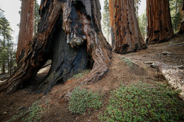
Burned, hollowed out base of a sequoia tree in Sequoia National Park
Burned, hollowed out base of a sequoia tree in Sequoia National Park
Burned, hollowed out base of a sequoia tree in Sequoia National Park

RestoreNet outplanted seedlings (left) v. direct seeding with soil surface treatments (right)
Left: RestoreNet outplant trials with greenhouse-grown seedlings planted into the field, Right: RestoreNet direct seeding trials with seeds combined with soil surface modifications including ConMod artificial nurse plants, mulch, and soil pits. Photos by Katie Laushman (USGS).
Left: RestoreNet outplant trials with greenhouse-grown seedlings planted into the field, Right: RestoreNet direct seeding trials with seeds combined with soil surface modifications including ConMod artificial nurse plants, mulch, and soil pits. Photos by Katie Laushman (USGS).
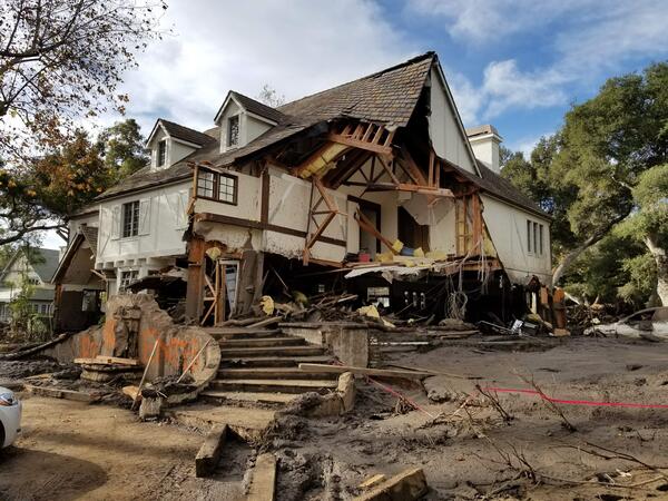
Montecito home damaged by post-wildfire debrisflow.
Damage from a major post-wildfire landslide that occurred on 9 January 2018 near Montecito, Santa Barbara County as a result of the 2017 Thomas Fire.
Damage from a major post-wildfire landslide that occurred on 9 January 2018 near Montecito, Santa Barbara County as a result of the 2017 Thomas Fire.

Christie Hegermiller geared up for beach elevation survey
Christie gears up to survey beach elevation in Santa Cruz, CA with a precise and accurate GPS unit mounted to her backpack. The GPS unit on her backpack communicates with a nearby "base station" to minimize errors in location.
Christie gears up to survey beach elevation in Santa Cruz, CA with a precise and accurate GPS unit mounted to her backpack. The GPS unit on her backpack communicates with a nearby "base station" to minimize errors in location.